The All New Postcode & Parliamentary Constituency Excel Spreadsheet
Product Page: Postcode & Constituency lookup data
For a number of years, we have sourced Postcode and Parliamentary information for our customers and created authoritative lookup tables and lists that relate UK Postcode geography to the various political structures across the UK.
As a result of customer feedback and work we have done for specific clients over the past few months, we are excited to announce that the latest update provides more information than ever before and is now available in an easy to use Excel format! Continue reading to what this latest release of Postcodes & Constituencies now provides.

Every UK Postcode
The product still contains every UK Postcode that has ever existed - over 1.7 million Postcodes and over 700,000 'retired' Postcodes which are no longer in use by Royal Mail.
This means when you need to check Parliamentary information for a Postcode which is no longer in use, you can still determine the constituency it fell within and the current MP and party holding that seat.
Westminster Constituencies
Every Postcode is linked to the current Westminster Parliamentary Constituency it falls within along with the Member of Parliament and Party that currently holds the seat. The current information is based upon the May 2015 General Election but accounts for any updates due to by-elections up to the point of the update.

Scottish Constituencies
For Postcodes in Scotland, we have always provided the name of the Scottish Constituency the Postcode falls within. In this latest release however, we have also included the name and party of the Scottish MP together with the name of the Scottish Parliament Region.

Each region is a group of constituencies, and the D'Hondt method of allocating additional member seats from party lists is used to produce a form of proportional representation for each region. Therefore, we also provide a separate sheet which provides the list of Scottish Regions and the elected Regional MSPs for each.

Welsh Assembly
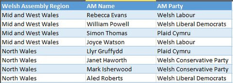
For Postcodes in Wales, we have always provided the name of the Welsh Assembly the Postcode falls within. In this latest release however, we have also included the name and party of the Assembly Member together with the name of the Welsh Assembly Region.

In addition, Assembly constituencies are grouped into electoral regions, and an additional member system is used to elect four additional Assembly Members (AMs) from each region, in addition to the AMs elected by the constituencies. Therefore, we also provide a separate sheet which provides the list of Welsh Assembly Regions and the elected AMs for each.

Northern Ireland MLAs
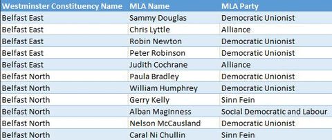
This sheet contains the Member of the Legislative Assembly (MLA) names and parties for Northern Ireland. The constituencies for Northern Ireland are the same as the Westminster Constituencies.

The role of the MLAs is primarily to scrutinize and make decisions on the issues dealt with by Government Departments and to consider and make legislation. There are multiple MLA’s for each constituency and the sheet Northern Ireland MLAs contains a record for each MLA with the associated Party and Constituency name.
Excel & CSV Text Formats

Old versions of Excel (versions up to and including Excel 2003) were limited to only 65,536 rows of information and therefore trying to squeeze 2.5 million Postcode rows into Excel was effectively impossible. However, Excel 2007 and later versions allow over 1 million rows per worksheet which means we can now provide the Postcode & Constituency data across 3 sheets in a single Excel workbook (Note: you must have Excel version 2007 or later to be able to open the spread sheet).
Excel makes the data easier to use and search, in particular by using the Excel Data Form tool to search for Postcode records and also reduces the amount of space required to store the data.
Both CSV and Excel options of the data are available for the same licence fee and further details can be found on the Postcode & Parliamentary Data product page.
