0 Cart
Added to Cart
    You have items in your cart
    You have 1 item in your cart
    Total
    Check Out Continue Shopping

    News — postcode

    November 2015 Postcode Changes

    The documents linked to below detail the latest November 2015 Postcode changes and address statistics for reference.

    Business & Vacant Organisations

    This table shows the number of businesses and vacant organisations on the Royal Mail address database, the Postcode Address File (PAF®). The table compares the latest month's figures with those from the previous month, identifying the percentage variation between the months. Download >

    PAF® Delivery Point Changes

    This document shows the number of delivery point additions, deletions and changes and the reasons for the change.
    Download >

    New Sectors & Localities

    This table shows the sectors and localities applied to the Postcode Address File (PAF®) system this month.
    Download >

    Overall PAF Statistics and Changes

    This table shows the total numbers of, and number of changes to, Postcodes, localities, Post Towns, delivery points and other PAF elements. Download >

    New Postcode Lists, Lookups and Addresses

    To complement our range of Postcode Area maps, we have made available a range of Postcode and address lists in Excel format to help you with your Postcode planning.

    We have three lists described below which can be used for common business tasks such as:

    1. Checking and validating Postcodes
    2. Cross reference Postcodes to local authorities and other geographies
    3. Locating Postcodes in GIS and mapping software
    4. Cleaning customer addresses to ensure accurate and successful mailings

    There are three files available for immediate download:

    Free Postcode Lists

    Aberdeen Postcode List Specification Download Aberdeen Postcode List Sample

    Free lists of all currently valid Postcodes in the Postcode Areas of the UK. These lists are updated every 3 months and you will receive a notification to download the updated version completely free of charge!

    Use For: Validating Postcodes or as a simple Postcode lookup list.

    Postcode Lists With Lookup Locations

    Aberdeen Postcode List with Locations Specification Aberdeen Postcode Location Lookup Sample

    This list contains a wealth of information about the Postcodes in each Postcode Area. Not only does it contain all the Postcodes currently in use by Royal Mail but it contains every Postcode that ever existed including when the Postcode was retired.

    Use For: Validating Postcodes, plotting Postcodes in mapping systems and identifying the parish, ward, local authority district that each Postcode belongs to.

    The file provides the following information for each Postcode (where the information is available*):

    • Postcode Sector
    • Postcode District
    • Postcode Area
    • Built Up Area Sub Division
    • Built Up Area
    • Ward
    • Parish
    • Local Authority District
    • Traditional County Name
    • Region
    • British National Grid Easting
    • British National Grid Northing
    • Latitude
    • Longitude
    • Date Postcode was introduced
    • Date Postcode was retired/ terminated

    * Fields can be blank in the data for a variety of reasons. The Postcode may be new and not have been cross-referenced to other geographies, agencies may not have supplied the information yet or the field my just not be relevant for that Postcode (not all areas are Parished for example).

    This file is also updated every 3 months and updates are included in the annual subscription fee.

    Postcode Lists With Addresses

    Aberdeen Postcode Address List Specification Aberdeen Postcode Address List Sample

    A spread sheet of every residential and business postal address in the respective Postcode Area. The information is sourced directly from Royal Mail and updated every 3 months to ensure it is up to date and accurate.

    Use For: Validating addresses and cleaning customer address records or as a simple address lookup list.

    The spreadsheet contains the following address fields:

    • UDPRN
    • Organisation Name
    • Department Name
    • PO Box
    • Building Name
    • Sub-Building Name
    • Building Number
    • Thoroughfare
    • Street
    • Double Dependent Locality
    • Dependent Locality
    • Post Town
    • Postcode
    • Postcode Type
    • DPS
    • SU Organisation Flag

    This file is also updated every 3 months and updates are included in the annual subscription fee.

    To download your Postcode and address lists today, simply pick your Postcode Area from the full UK list >

    The All New Postcode & Parliamentary Constituency Excel Spreadsheet

    Product Page: Postcode & Constituency lookup data

    For a number of years, we have sourced Postcode and Parliamentary information for our customers and created authoritative lookup tables and lists that relate UK Postcode geography to the various political structures across the UK.

    As a result of customer feedback and work we have done for specific clients over the past few months, we are excited to announce that the latest update provides more information than ever before and is now available in an easy to use Excel format! Continue reading to what this latest release of Postcodes & Constituencies now provides.

     UK Parliamentary Map

    Every UK Postcode

    The product still contains every UK Postcode that has ever existed - over 1.7 million Postcodes and over 700,000 'retired' Postcodes which are no longer in use by Royal Mail.

    This means when you need to check Parliamentary information for a Postcode which is no longer in use, you can still determine the constituency it fell within and the current MP and party holding that seat.

     Westminster Constituencies

    Every Postcode is linked to the current Westminster Parliamentary Constituency it falls within along with the Member of Parliament and Party that currently holds the seat. The current information is based upon the May 2015 General Election but accounts for any updates due to by-elections up to the point of the update.

    Postcodes & Westminster Parliamentary Constituencies

    Scottish Constituencies

    For Postcodes in Scotland, we have always provided the name of the Scottish Constituency the Postcode falls within. In this latest release however, we have also included the name and party of the Scottish MP together with the name of the Scottish Parliament Region.

    Postcode to Scottish Parliamentary Constituency

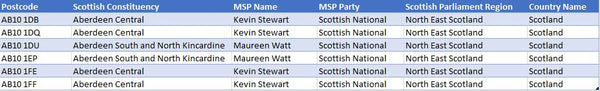
    Each region is a group of constituencies, and the D'Hondt method of allocating additional member seats from party lists is used to produce a form of proportional representation for each region. Therefore, we also provide a separate sheet which provides the list of Scottish Regions and the elected Regional MSPs for each.
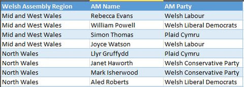
     Scottish Parliamentary Regions

    Welsh Assembly

    For Postcodes in Wales, we have always provided the name of the Welsh Assembly the Postcode falls within. In this latest release however, we have also included the name and party of the Assembly Member together with the name of the Welsh Assembly Region. 

    Postcode to Welsh Assembly

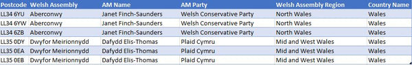
    In addition, Assembly constituencies are grouped into electoral regions, and an additional member system is used to elect four additional Assembly Members (AMs) from each region, in addition to the AMs elected by the constituencies. Therefore, we also provide a separate sheet which provides the list of Welsh Assembly Regions and the elected AMs for each.

    Welsh Assembly Regions

    Northern Ireland MLAs

    This sheet contains the Member of the Legislative Assembly (MLA) names and parties for Northern Ireland. The constituencies for Northern Ireland are the same as the Westminster Constituencies.

    Northern Ireland MLAs

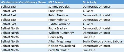
    The role of the MLAs is primarily to scrutinize and make decisions on the issues dealt with by Government Departments and to consider and make legislation. There are multiple MLA’s for each constituency and the sheet Northern Ireland MLAs contains a record for each MLA with the associated Party and Constituency name.

    Excel & CSV Text Formats

    Microsoft Excel

    Old versions of Excel (versions up to and including Excel 2003) were limited to only 65,536 rows of information and therefore trying to squeeze 2.5 million Postcode rows into Excel was effectively impossible. However, Excel 2007 and later versions allow over 1 million rows per worksheet which means we can now provide the Postcode & Constituency data across 3 sheets in a single Excel workbook (Note: you must have Excel version 2007 or later to be able to open the spread sheet).

    Excel makes the data easier to use and search, in particular by using the Excel Data Form tool to search for Postcode records and also reduces the amount of space required to store the data.

    Both CSV and Excel options of the data are available for the same licence fee and further details can be found on the Postcode & Parliamentary Data product page.


    2015 Election Postcodes by Parliamentary Constituency

    The 2015 General Election threw up more surprises than expected with a clear majority for the Conservative party, the domination of Scotland by the Scottish National Party, the catastrophic performance by the Liberal Democrats and the impressive total vote count for UKIP which amazingly resulted in just a single Parliamentary Seat!

    Following the confirmed election results we have updated our core Postcode to Parliamentary Constituency data products and look at the impact of the May General Election in the United Kingdom from a Postcode Point Of View.

    Finding MPs by Postcode

    With so many key seats changing hands, obviously many constituencies found themselves with new Members of Parliament for the next term. In fact, we had a change of 185 MP's across the country as a result of seats being won and lost or just a change of MP within the party. As a result, this meant that a staggering 510,591 current Postcodes across England, Scotland, Wales and Northern Ireland now have a new MP - this is almost 30% of the entire number of Postcodes in the Country.

    The largest proportion of changes was obviously in Scotland where the Scottish National Party swept (almost) all before them but the actual number of Postcodes with a new MP by country is shown as follows:

    England: 335,830
    Northern Ireland: 15,238
    Scotland: 132,161
    Wales: 27,362

    Postcodes By Political Party

    Similarly, we can determine that 367,475 Postcodes across the UK (21%) now have a new party representing them in Westminster. Breaking this figure down to show the Postcodes gained by each political party shows the impact of the SNP on the 2105 Election.

    Conservative: 102,806
    Democratic Unionist: 2,064
    Labour: 63,194
    Labour Co-op: 57,069
    Scottish National: 132,161
    UKIP: 2,672
    Ulster Unionist Party: 7,509

    The absence of parties including the Liberal Democrats just shows that these parties did not gain any new Postcodes as a result of the election. To confirm, the above figures are the total number of Postcodes acquired - not the net gain of Postcodes.

    Postcode to Parliamentary Lookup

    Data such as the Postcode to Parliamentary Constituency database has become invaluable to companies analysing their own geographic and political footprint and also within the Public and Government Relations arenas. It underpins common questions such as "which constituencies are most important to our business" and "what constituency am I in by Postcode?"

    Contact us for more information on Postcode analysis of the 2015 Election or details on our other Postcode based look up tables and analysis.

    Free Postcode Maps On Google Maps

    We have been playing with google maps to provide a simple and free online Postcode map resource for quite some time.

    After some review about how to best make this work - in particular with some Google Maps limitations - we are trying out a new site which is dedicated to the provision of free online Postcode maps.


    Currently the site utilises the Google Maps search tool to allow you to search for a town, Postcode or county in the UK and display the Postcode Districts or Sectors for that area. Postcode District and Sector boundaries can be toggled on or off on the map by simple buttons in the top right of the map.

    In addition, there are menu options to view predefined Postcode maps for selected towns, Postcode Areas and Counties.

    We hope this is the first phase of an on-going Postcode mapping development and, as such, we have a competition running for visitors to give us their feedback on what they would like the site to do next. These responses will help drive the next features we will look to add to the site over the coming months either free of charge or for a small subscription fee.

    We welcome all feedback on the site so please hop over to have a look and use one of the methods on the site to let us know what you think and how you think the site could be improved.

    Thanks in advance :-)

    Read more