0 Cart
Added to Cart
    You have items in your cart
    You have 1 item in your cart
    Total
    Check Out Continue Shopping

    News

    2015 Election Postcodes by Parliamentary Constituency

    The 2015 General Election threw up more surprises than expected with a clear majority for the Conservative party, the domination of Scotland by the Scottish National Party, the catastrophic performance by the Liberal Democrats and the impressive total vote count for UKIP which amazingly resulted in just a single Parliamentary Seat!

    Following the confirmed election results we have updated our core Postcode to Parliamentary Constituency data products and look at the impact of the May General Election in the United Kingdom from a Postcode Point Of View.

    Finding MPs by Postcode

    With so many key seats changing hands, obviously many constituencies found themselves with new Members of Parliament for the next term. In fact, we had a change of 185 MP's across the country as a result of seats being won and lost or just a change of MP within the party. As a result, this meant that a staggering 510,591 current Postcodes across England, Scotland, Wales and Northern Ireland now have a new MP - this is almost 30% of the entire number of Postcodes in the Country.

    The largest proportion of changes was obviously in Scotland where the Scottish National Party swept (almost) all before them but the actual number of Postcodes with a new MP by country is shown as follows:

    England: 335,830
    Northern Ireland: 15,238
    Scotland: 132,161
    Wales: 27,362

    Postcodes By Political Party

    Similarly, we can determine that 367,475 Postcodes across the UK (21%) now have a new party representing them in Westminster. Breaking this figure down to show the Postcodes gained by each political party shows the impact of the SNP on the 2105 Election.

    Conservative: 102,806
    Democratic Unionist: 2,064
    Labour: 63,194
    Labour Co-op: 57,069
    Scottish National: 132,161
    UKIP: 2,672
    Ulster Unionist Party: 7,509

    The absence of parties including the Liberal Democrats just shows that these parties did not gain any new Postcodes as a result of the election. To confirm, the above figures are the total number of Postcodes acquired - not the net gain of Postcodes.

    Postcode to Parliamentary Lookup

    Data such as the Postcode to Parliamentary Constituency database has become invaluable to companies analysing their own geographic and political footprint and also within the Public and Government Relations arenas. It underpins common questions such as "which constituencies are most important to our business" and "what constituency am I in by Postcode?"

    Contact us for more information on Postcode analysis of the 2015 Election or details on our other Postcode based look up tables and analysis.

    Happy Anniversary - The Broads

    The Broads National Park

    On this day in 1989, The Broads was confirmed as a National Park so Happy Anniversary today to The Broads!

    The broads covers the towns of Stalham, Wroxham, Brundall, Acle, Loddon, Beccles and Oulton Broad and receives approximately 8 million visitors each year visiting 13 ancient monuments and 18 conservation areas.

    The Broads is actually the smallest National Park covering just 303 square kilometres and is also the lowest National Park with its highest point, Bath Hills, at just 30 metres above sea level.

    The definitive large wall map of The Broads can be purchased here >

    An Antique World Map Masterpiece

    You don't have to like maps to appreciate this work of art!

    Willem Blaeu, the famous Dutch cartographer and appointed map maker for the Dutch East India Company, had two sons Johannes (Joan) and Cornelius Blaeu who continued his map making business after his death in 1638. This stunning world map was published circa 1665 although we can't determine how much of the map is Willem's or his sons work.

    The map is famous for its elaborate ornamentation, embellished with ships, sea monsters, compass roses, and ornate border panel.

    The map incorporates some of the classic early 17th Century cartographic misconceptions, including California shown as a separate island to the North American mainland, the lack of coastal detail around Alaska and NW America, a narrow strait between North and South America and so on.

    Whether you like perusing old maps or just want a wall display to finish off an office or a sitting room,  this huge map provides an historic elegance and style to any room without dominating too much.

    For more information visit our Blaeu World map product page.


    9 Poldark Filming Locations

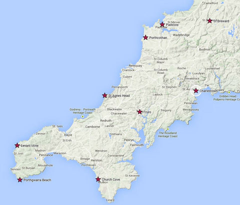
    Watching the first episode of the new BBC Poldark production last night, we were reminded of the stunning scenery and landscapes of Cornwall and spent most of the programme trying to work out where they were.

    So we did a bit of research courtesy of the BBC and came up with a nice little map. So for all the Poldark lovers out there who may be planning a visit to Cornwall in the near future, we thought we would share this simple interactive map to help plan your route around the county. And if anyone knows exactly where Ross Poldarks cottage Nampara actually is (we only know it is somewhere near St Breward) then let us know!

    Enjoy!

    Poldark filming locations in Cornwall

    Poldark filming locations in Cornwall

    Win a Map of Wales!

    The 1st March is St David's day - the national day of Wales - chosen as St David died on the 1st March 589 AD in St David's, Pembrokeshire. To commemorate this important date in Welsh history, we are giving away a free map of Wales to the winner of this weeks competition.

    One lucky winner can win a map of their choice from our range of maps for Wales >

    How To Enter

    Simply follow the link above and  answer the question "What does the Welsh motto "Cymru am byth" translates to in English"?

    The winner will be chosen at random at 18:00 on Friday 6th March and will be notified by their chosen method of entry.

    Good Luck!