0 Cart
Added to Cart
    You have items in your cart
    You have 1 item in your cart
    Total
    Check Out Continue Shopping

    News

    Top 10 Maps and Atlases For Christmas

    OK - so we know that a rolled up Postcode Map of Doncaster in your loved ones stocking is probably not going to get you the warmest response this Christmas! But maps can be a great and affordable stocking filler - especially for the young explorer or people with special interests.

    Here we look at this years top 10 bestselling maps and atlases which could find their way into homes this Christmas - courtesy of Amazon.

    #1 - Vargic's Miscellany of Curious Maps: The Atlas of Everything You Never Knew You Needed to Know

    This is a wonderfully unusual and fascinating book created by 17 year old Slovakian, Martin Vargic.

    Martin maps the world out in a collection of 64 maps to illustrate the diversity of culture and technology including:

    1. The map of stereotypes
    2. Maps of Internet, YouTube ands gaming
    3. Maps of literature, sport and music
    4. and many more

    The book receives rave reviews for it's beauty and insane ingenuity!


    #2 - The Usborne Children's Picture Atlas

    This is currently the best selling children's Atlas. So if you are looking for a great present for the young explorers out there, this would be the current pick of the crop.

    Superbly illustrated and packed with information over 48 pages to inspire and excite the youngest minds.

    Geography: children can find it boring, right? Well, not if they have this picture atlas, which takes readers on a cartoon-illustrated tour of the world, cramming lots of child-friendly facts on the thematically organised pages --The Independent


    The maps here provide the perfect inspiration to would-be adventurers. --wearandwhere.com


    From Mayan temples in Mexico to albatross in Antarctica, you can explore the four corners of the globe while still tucked up in bed. --Little London

    Fantastic reviews make this atlas a safe purchase for Christmas.


    #3 - A Walk In The Woods: The World's Funniest Travel Writer Takes a Hike

    Maybe technically not a map or an Atlas; but Bill Bryson has huge appeal to those with a love of exploration and this book will be loved by anyone who has picked up a map, donned walking boots and headed out into the great unknown.

    2,200 miles of bears, moose, snakes and the occasional murderer is not a Sunday stroll on Dartmoor and Bryson tells the tale of his adventure in his usual easy-to-read irreverent way.

    Read more...

    The perfect book for a relaxing Boxing Day read.


    #4 - Big Road Atlas Britain 2016 (AA Big Road Atlas)

    Old Faithful! 

    The 25th edition of the best selling A3 format road atlas of the British Isles; spiral bound with 160 pages of detail road maps.

    Everything you need to know to find your way around the nations roads and an atlas every driver should have in their glove box - even if they do have a SatNav!

    Clear mapping, easy to read - the perfect stocking filler!


    #5 - 100 Greatest Cycling Climbs: A Road Cyclist's Guide to Britain's Hills

    Cycling has fast become one of the most popular British pastimes and this book is the perfect gift for the cyclist in your family.

    Detailing 100 climbs and hills to test the most ardent cyclist, this book provides maps, timings and ratings from cobbled streets to mountain passes so you are sure to find a route near you.

    Of course, this could also be used for those wishing to avoid any rides that are too taxing!

    Get the full description and reviews at Amazon >


    #6 - Grand Prix Circuits: Maps and statistics from every Formula One track

    The perfect gift for the F1 fan in your house or the budding Lewis Hamilton.

    It may feel like a bit of a tenuous link to maps and atlases but this book does contain circuit maps created by cartographic specialists Collins for each of the 71 tracks that have ever hosted a Grand Prix - who said maps were boring?

    Each map is coupled with statistics, photographs, lap records and much more. This will keep the biggest fan quiet through tot he New Year....

    Get the full description and reviews at Amazon >


    #7 - Deep South: Four Seasons on Back Roads

    Another surprising entry into a top 10 list of Maps and Atlases but Paul Theroux's guide to the southern states of the USA is another widely acclaimed travel book.

    Not only is it in Amazon's top 10 but it is also in the top 10 of the Sunday Times!

    If you know someone who has ever travelled to the southern states - or wanted to

    Get the full description and reviews at Amazon >


    #8 - The Ladybird Book of London (Ladybird Archive)

    May be a gift for the more mature relative who likes a wander down memory lane!

    This Ladybird book was originally published in 1961 but has been born again in all its glory complete with full page illustrations and facts about England's capital city.

    A great little stocking filler for those who remember the 60's!

    Get the full description and reviews at Amazon >


    #9 - Great Maps

    Well, the title says it all!

    The history of maps, ancient maps, internet maps. The stories of some of the greatest maps ever produced and full of fascinating facts and figures about how maps have influenced our world.

    If you know someone who wants to know the answers to questions such as:

    • Why do we put North at the top of maps?
    • Which map shows the land of no sunshine? and more importantly
    • Which map shows the land of people with no bowels

    Then this book is for them!

    Get the full description and reviews at Amazon >


    #10 - Drink London

    What Christmas map list would be complete without a reference to our favourite pastime?

    This is a great book for anyone who likes to find those secret places in London and enjoys a tipple whilst they are doing it.

    A great guide book with lovely photography and of course maps to help you find the next bar. The perfect gift for your London based socializing friends.

    Get the full description and reviews at Amazon >


    November 2015 Postcode Changes

    The documents linked to below detail the latest November 2015 Postcode changes and address statistics for reference.

    Business & Vacant Organisations

    This table shows the number of businesses and vacant organisations on the Royal Mail address database, the Postcode Address File (PAF®). The table compares the latest month's figures with those from the previous month, identifying the percentage variation between the months. Download >

    PAF® Delivery Point Changes

    This document shows the number of delivery point additions, deletions and changes and the reasons for the change.
    Download >

    New Sectors & Localities

    This table shows the sectors and localities applied to the Postcode Address File (PAF®) system this month.
    Download >

    Overall PAF Statistics and Changes

    This table shows the total numbers of, and number of changes to, Postcodes, localities, Post Towns, delivery points and other PAF elements. Download >

    October Postcode Changes

    Why Do Postcodes Change?

    The Postcode system changes continually with around 1.25 million address changes in an average year. As a result, Royal Mail are forced to make changes to the Postcode system in order to maintain postal delivery efficiency.

    For example, new housing developments or business parks in already densely populated areas can leave no free postcodes for Royal Mail to allocate. this can lead to the recoding of a wider area to create additional codes to allocate.

    Postcode Changes For October 2015

    The documents linked to below detail the latest Postcode changes and address statistics for reference.

    Business & Vacant Organisations

    This table shows the number of businesses and vacant organisations on the Royal Mail address database, the Postcode Address File (PAF®). The table compares the latest month's figures with those from the previous month, identifying the percentage variation between the months. > Download

    PAF® Delivery Point Changes

    This document shows the number of delivery point additions, deletions and changes and the reasons for the change.
    > Download

    New Sectors & Localities

    This table shows the sectors and localities applied to the Postcode Address File (PAF®) system this month.
    > Download

    Overall PAF Statistics and Changes

    This table shows the total numbers of, and number of changes to, Postcodes, localities, Post Towns, delivery points and other PAF elements. > Download

    New Postcode Lists, Lookups and Addresses

    To complement our range of Postcode Area maps, we have made available a range of Postcode and address lists in Excel format to help you with your Postcode planning.

    We have three lists described below which can be used for common business tasks such as:

    1. Checking and validating Postcodes
    2. Cross reference Postcodes to local authorities and other geographies
    3. Locating Postcodes in GIS and mapping software
    4. Cleaning customer addresses to ensure accurate and successful mailings

    There are three files available for immediate download:

    Free Postcode Lists

    Aberdeen Postcode List Specification Download Aberdeen Postcode List Sample

    Free lists of all currently valid Postcodes in the Postcode Areas of the UK. These lists are updated every 3 months and you will receive a notification to download the updated version completely free of charge!

    Use For: Validating Postcodes or as a simple Postcode lookup list.

    Postcode Lists With Lookup Locations

    Aberdeen Postcode List with Locations Specification Aberdeen Postcode Location Lookup Sample

    This list contains a wealth of information about the Postcodes in each Postcode Area. Not only does it contain all the Postcodes currently in use by Royal Mail but it contains every Postcode that ever existed including when the Postcode was retired.

    Use For: Validating Postcodes, plotting Postcodes in mapping systems and identifying the parish, ward, local authority district that each Postcode belongs to.

    The file provides the following information for each Postcode (where the information is available*):

    • Postcode Sector
    • Postcode District
    • Postcode Area
    • Built Up Area Sub Division
    • Built Up Area
    • Ward
    • Parish
    • Local Authority District
    • Traditional County Name
    • Region
    • British National Grid Easting
    • British National Grid Northing
    • Latitude
    • Longitude
    • Date Postcode was introduced
    • Date Postcode was retired/ terminated

    * Fields can be blank in the data for a variety of reasons. The Postcode may be new and not have been cross-referenced to other geographies, agencies may not have supplied the information yet or the field my just not be relevant for that Postcode (not all areas are Parished for example).

    This file is also updated every 3 months and updates are included in the annual subscription fee.

    Postcode Lists With Addresses

    Aberdeen Postcode Address List Specification Aberdeen Postcode Address List Sample

    A spread sheet of every residential and business postal address in the respective Postcode Area. The information is sourced directly from Royal Mail and updated every 3 months to ensure it is up to date and accurate.

    Use For: Validating addresses and cleaning customer address records or as a simple address lookup list.

    The spreadsheet contains the following address fields:

    • UDPRN
    • Organisation Name
    • Department Name
    • PO Box
    • Building Name
    • Sub-Building Name
    • Building Number
    • Thoroughfare
    • Street
    • Double Dependent Locality
    • Dependent Locality
    • Post Town
    • Postcode
    • Postcode Type
    • DPS
    • SU Organisation Flag

    This file is also updated every 3 months and updates are included in the annual subscription fee.

    To download your Postcode and address lists today, simply pick your Postcode Area from the full UK list >

    The All New Postcode & Parliamentary Constituency Excel Spreadsheet

    Product Page: Postcode & Constituency lookup data

    For a number of years, we have sourced Postcode and Parliamentary information for our customers and created authoritative lookup tables and lists that relate UK Postcode geography to the various political structures across the UK.

    As a result of customer feedback and work we have done for specific clients over the past few months, we are excited to announce that the latest update provides more information than ever before and is now available in an easy to use Excel format! Continue reading to what this latest release of Postcodes & Constituencies now provides.

     UK Parliamentary Map

    Every UK Postcode

    The product still contains every UK Postcode that has ever existed - over 1.7 million Postcodes and over 700,000 'retired' Postcodes which are no longer in use by Royal Mail.

    This means when you need to check Parliamentary information for a Postcode which is no longer in use, you can still determine the constituency it fell within and the current MP and party holding that seat.

     Westminster Constituencies

    Every Postcode is linked to the current Westminster Parliamentary Constituency it falls within along with the Member of Parliament and Party that currently holds the seat. The current information is based upon the May 2015 General Election but accounts for any updates due to by-elections up to the point of the update.

    Postcodes & Westminster Parliamentary Constituencies

    Scottish Constituencies

    For Postcodes in Scotland, we have always provided the name of the Scottish Constituency the Postcode falls within. In this latest release however, we have also included the name and party of the Scottish MP together with the name of the Scottish Parliament Region.

    Postcode to Scottish Parliamentary Constituency

    Each region is a group of constituencies, and the D'Hondt method of allocating additional member seats from party lists is used to produce a form of proportional representation for each region. Therefore, we also provide a separate sheet which provides the list of Scottish Regions and the elected Regional MSPs for each.

     Scottish Parliamentary Regions

    Welsh Assembly

    For Postcodes in Wales, we have always provided the name of the Welsh Assembly the Postcode falls within. In this latest release however, we have also included the name and party of the Assembly Member together with the name of the Welsh Assembly Region. 

    Postcode to Welsh Assembly

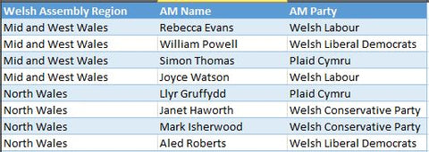
    In addition, Assembly constituencies are grouped into electoral regions, and an additional member system is used to elect four additional Assembly Members (AMs) from each region, in addition to the AMs elected by the constituencies. Therefore, we also provide a separate sheet which provides the list of Welsh Assembly Regions and the elected AMs for each.

    Welsh Assembly Regions

    Northern Ireland MLAs

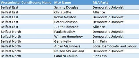
    This sheet contains the Member of the Legislative Assembly (MLA) names and parties for Northern Ireland. The constituencies for Northern Ireland are the same as the Westminster Constituencies.

    Northern Ireland MLAs

    The role of the MLAs is primarily to scrutinize and make decisions on the issues dealt with by Government Departments and to consider and make legislation. There are multiple MLA’s for each constituency and the sheet Northern Ireland MLAs contains a record for each MLA with the associated Party and Constituency name.

    Excel & CSV Text Formats

    Microsoft Excel

    Old versions of Excel (versions up to and including Excel 2003) were limited to only 65,536 rows of information and therefore trying to squeeze 2.5 million Postcode rows into Excel was effectively impossible. However, Excel 2007 and later versions allow over 1 million rows per worksheet which means we can now provide the Postcode & Constituency data across 3 sheets in a single Excel workbook (Note: you must have Excel version 2007 or later to be able to open the spread sheet).

    Excel makes the data easier to use and search, in particular by using the Excel Data Form tool to search for Postcode records and also reduces the amount of space required to store the data.

    Both CSV and Excel options of the data are available for the same licence fee and further details can be found on the Postcode & Parliamentary Data product page.