Postcode Updates, The 2017 General Election, EU Referendum Results and Ceremonial Counties

Postcode information, like any dynamic data, is continually changing and evolving which is why keeping Postcode information up to date is essential for many businesses that rely upon it. As part of our commitment to keep our customers up to date, we source and apply the latest Postcode and Government information updates to all of our data and map products every 3 months.
![]()
For the latest update, we have also made a few changes to products as a result of customer feedback and requests.
Parliamentary Constituency Data & The 2017 General Election
The latest Parliamentary Constituency data includes all the latest Postcode changes and the status of MP's and Parties at the dissolution of Parliament on Wednesday 3rd May 2017.
The MP changes to the database over the previous 3 months were as a result of By-Elections in the following constituencies.
Copeland was won on 23rd February 2017 by Trudy Harrison in a Conservative gain as a result of the retirement of Jamie Reed.
Stoke-on-Trent Central was won on 23rd February 2017 by Gareth Snell in a Labour hold as a result of the retirement of Tristram Hunt.
Manchester Gorton is currently vacant as a result of the death of Sir Gerald Kaufman and will be contested at the General Election on 8th June 2017.
We have been asked how soon this product will be updated after the General Election and, as with the General Election of 2015, we will be applying an immediate update once all results are finalised. We expect to release this by Friday 16th June 2017.
The information is available as Postcode lists in Access, Excel or CSV format or as a Postcode to Constituency Excel matching spread sheet which automatically appends constituency information to your list of Postcodes.
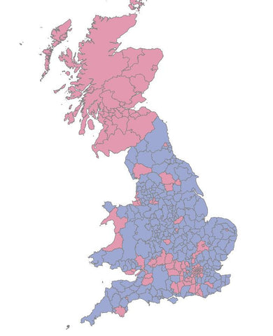
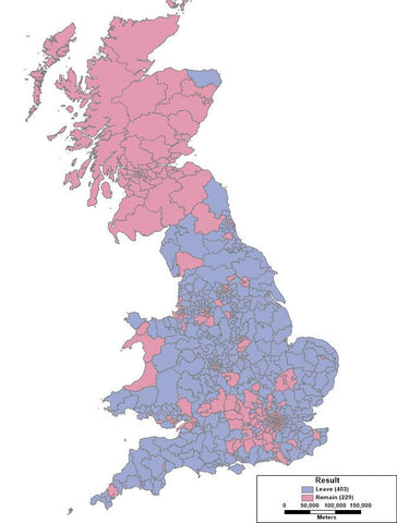
EU Referendum Results
 For the EU Referendum on 23rd June 2016, Local authorities weren’t required to publish the results of the EU Referendum by Parliamentary constituency or by ward and, in most cases, they sub-divided their count process which removed the possibility to get ward or constituency breakdowns.
Nevertheless, some local authorities did publish the results by ward and Parliamentary constituency and Northern Ireland also published the results of the referendum for each of its 18 constituencies.
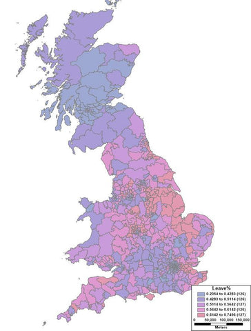
Because of the lack of local results for the EU referendum by Parliamentary Constituency, estimates published by Dr Chris Hanretty of the University of East Anglia are often used to analyse the results at constituency level. Dr Hanretty modelled the results by determining the relationship between the population demographics of local authorities and their referendum results, and then using this profile to project the results for each constituency based on the characteristics of its demographic profile.
Subsequently, the BBC also asked all local authorities in charge of counting the result in their area for voting figures broken down by ward. Of the 1,283 wards the BBC were able to collect data for, 857 of these could be transformed into 107 Parliamentary constituencies to give precise, known, voting figures for the referendum in that area.
The EU Referendum results by constituency can be downloaded for free and it is also included with our Postcode to Parliamentary Constituency Lookup Table.
We have also added the spread sheet of EU Referendum results by Local Authority to our Postcode to Local Authority Lookup table.
You can also see a few simple maps of the EU Referendum results here >
Postcode to Ceremonial County Lookup
Due to popular demand, we have added ceremonial county names to our Postcode to County Lookup table.
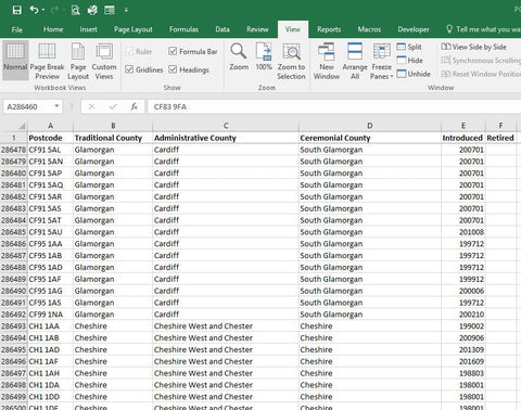
We have always included Administrative and Traditional County names, but to make the product complete we have now added Ceremonial county names. Therefore, no matter what your application or requirement for county names - we have the county name for you!
You can read more about the Postcode to county lookup file here and why there is a county name confusion at all here!
How Do Updates Affect Postcode Products?
Changes to Postcodes have a direct impact on a whole range of Postcode based products which must be updated to reflect the ever-changing Postcode landscape. Here are some examples of how Postcode changes may affect you:
If you use Postcodes for Business Analysis
Look up tables which relate Postcodes to other information such as Parliamentary Constituencies, Local Authority Information, Grid References must all be updated to ensure the analysis of Postcode related records and information is accurate and up to date.
In addition to updating the Postcodes themselves, we also take the opportunity to update all the related information such as MP names, Ward names and so on to ensure these references are also current.
If you use Postcodes for Address Management
Sometimes existing Postcodes do change for households and people move in to new build homes with brand new addresses and Postcodes. Companies providing services or delivering products to these homes need to ensure their systems are up to date to capture and update these new addresses.
Our Royal Mail PAF databases are therefore all updated to reflect the latest Postcode changes and help companies keep their customer data accurate and up to date.
If you use Postcodes for mapping Sales Territories or Franchise Areas
Changes to the Postcode system can also impact the Postcode boundaries themselves which are widely used in GIS and mapping software such as MapInfo, ESRI and Intergraph products for a range of business tasks including mapping sales territories and planning franchise areas.
New Postcodes can change the Postcode structure geographically and we meticulously review these changes to ensure all our digital Postcode boundary files reflect these latest changes.
The next Postcode update is expected to take place in June 2017 but if you have any questions on the latest Postcode changes and how they may affect you please contact us.